
ᓱᑲ ᐊᐢᑲᐤ
Lands
Department
The Lands Department manages, protects, and documents the territorial lands of Sucker Creek First Nation (IR 150A) for current and future generations.
DEPARTMENT OVERVIEW
Stewardship of Our Territory
DEPARTMENT DIRECTOR
Sandy Willier
Department Director
780-523-4426
Direct Line Extension 153
sandyw@scfn.ca
Mon–Fri: 8:30 AM – 4:30 PM
Office Hours
PROGRAMS & SERVICES
What We Offer
Occupational Certificates
Compiling Band Council Resolutions (BCRs) for Occupational Certificates, managing requests, processing transfers, and maintaining a secure filing system for member land records.
GIS Mapping & Data
Creating and maintaining comprehensive Geographic Information System (GIS) maps with multiple data layers to provide accurate information for new occupational certificate BCRs.
Member Consultations
Meeting directly with community members to discuss BCR information, land requests, boundary questions, and property transfers.
Historical Land Research
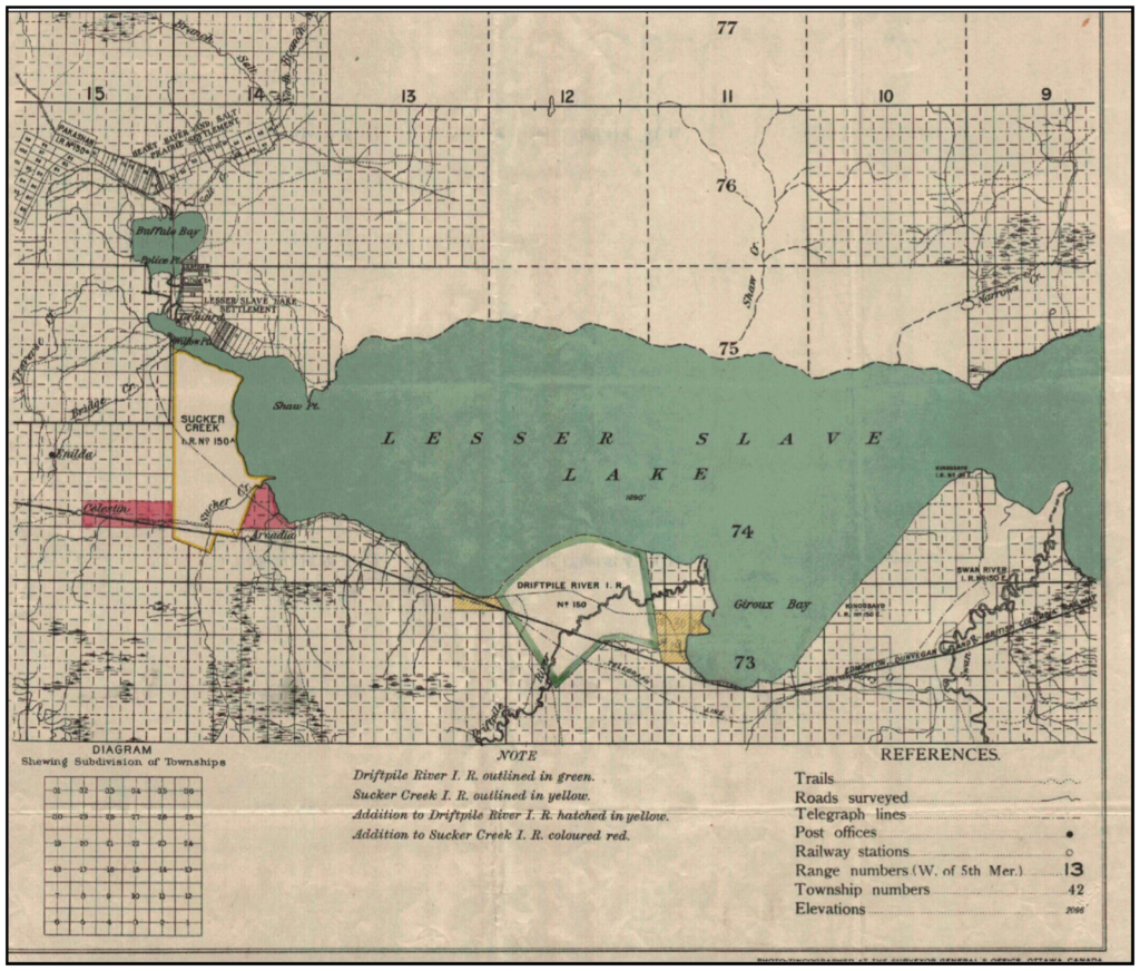
Documenting the history of Reserve 150A, including the original 1901 survey for Chief Kinoosayo's band, the 1913 additions to the reserve, and the original band member lists.
Treaty Land Entitlement (TLE)
Providing information and facilitating community discussions regarding Treaty Land Entitlement and the ongoing protection of Treaty 8 rights.
Land Description Assistance
Helping members understand Dominion Land Survey (DLS) legal descriptions, including sections, townships, ranges, and legal subdivisions (LSDs).
MEMBER RESOURCES
Understanding Our Lands
To support our members in understanding land management, we provide access to key resources and tools used in Canada Lands surveying.
Helpful Links & Tools:
Canada Lands Survey System (CLSS) Map Browser: An interactive map showing surveyed parcels and administrative boundaries of Canada Lands, including Sucker Creek 150A.
Survey Plan Search: A tool provided by Natural Resources Canada to find, view, and download official Canada Lands survey plans and records.
The Indian Act (R.S.C., 1985, c. I-5): Access to the consolidated federal legislation governing Indian status, bands, and Indian reserves.
(Note: If you require assistance using these tools or interpreting a legal land description, please contact the Lands Worker to set up an appointment.)
OUR HISTORY
The Creation of Reserve 150A
Need Assistance?
Contact the Land Department directly or reach us through the main band office.